 Exposing the lack of compassion by conservatives and
debunking right wing hypocrisy at every opportunity.
Exposing the lack of compassion by conservatives and
debunking right wing hypocrisy at every opportunity.


With Governor Palin on the GOP ticket, it occurs that among the top of the tickets, three of the contenders, McCain, Palin, and Obama are from the very last states admitted to the Union: Arizona (48th), Alaska (49th) and Hawaii (50th).
Any of those would be a first, but so would a Vice-President (or President for that matter) from Delaware if Joe Biden moves into the Naval Observatory. (He'd also be the first Catholic VP.)
By virtue of being the first of the original 13 colonies whose legislature ratified the US Constitution in 1787, little Delaware is the "First State." So by the law of averages or sheer dumb luck, it's pretty amazing that it's taken this long for them to be this close to having a Veep or Prez from this sliver of land between New Jersey and Maryland.
FOR ALL YOU MAP FANS (yes, you Nairb), there's some peculiar stuff I noticed on the Wiki about the northern boundaries of Delaware, just above where the state narrows to only 9 miles across between Delaware Bay and Maryland.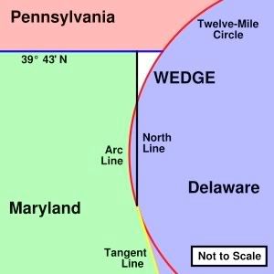
Believe it or not, the Delaware House of Representatives considered calling out their National Guard over the disputed gas facility while rubmlings came across the bay that the Battleship New Jersey might be called into action. Politicians really do love theater, don't they.
Even the idiosyncratic southern and western Delaware borders are noteworthy, dependant on the midway point of the "Transpeninsular Line" that stretches from Fenwick Island at the Ocean City, Maryland city limits, along the widest point of the "Delmarva Peninsula" (also shared by Virginia on the southern tip) and north from the centerpoint of that Transpeninsular Line towards the Pennsylvania border to a point tangent to the 12 Mile Circle.
Since technically, the north-south line forming the western border of Delaware is also part of the Mason-Dixon line separating Pennsylvania and Maryland, Delaware was the only slave-owning State "above" that border that marked the North from the South. However by the onset of the Civil War, Delaware was a slave state in name only and remained in the union, having all but eliminated slavery in practice if not by law.
BTW, while it's the second smallest state in land area, being the 7th most densely populated Delaware has more people than Palin's Alaska, the largest but most sparsely peopled state that ranks second only to Cheney's Wyoming in the smallest population.

Maybe this is just a quirk of mine, fascination with maps. But since I live in "Ohio Occupied Michigan," a block from Stickney Avenue (named for the heroes of the Toledo War), quirky borders always have a history that appeals to my inner geek. Just look at these two little pieces of Michigan (highlighted in red) that you can't get to unless you drive through Point Place, Ohio, a suburban Toledo neighborhood where two of my kids went to school.
Any of those would be a first, but so would a Vice-President (or President for that matter) from Delaware if Joe Biden moves into the Naval Observatory. (He'd also be the first Catholic VP.)
By virtue of being the first of the original 13 colonies whose legislature ratified the US Constitution in 1787, little Delaware is the "First State." So by the law of averages or sheer dumb luck, it's pretty amazing that it's taken this long for them to be this close to having a Veep or Prez from this sliver of land between New Jersey and Maryland.
FOR ALL YOU MAP FANS (yes, you Nairb), there's some peculiar stuff I noticed on the Wiki about the northern boundaries of Delaware, just above where the state narrows to only 9 miles across between Delaware Bay and Maryland.
"The definition of the northern boundary of the state is highly unusual.The disputed "Wedge" (now part of Delaware) is also interesting as well as the tip of a peninsula that would otherwise be a piece of New Jersey that juts into the Delaware estuary, crossing the Twelve-Mile Circle in the southeast. Unlike most river borders that mark control at the center, Delaware owns everything in the Delaware River right up to the low-water line on the Jersey shore -- a situation that has caused several disputes regarding that border ending up before the US. Supreme Court, the last of which was just decided in 2007 regarding who gets to tax a BP natural gas terminal despite the admonishment by the court in 1934 that they were sick of the two states quibbling over lines in the dirt.
Most of the boundary between Delaware and Pennsylvania is defined by an
arc extending 12 miles (19 km) from the cupola of the courthouse in New Castle. It is referred to as the Twelve-Mile Circle. This is the only true-arc political boundary in the United States."
Believe it or not, the Delaware House of Representatives considered calling out their National Guard over the disputed gas facility while rubmlings came across the bay that the Battleship New Jersey might be called into action. Politicians really do love theater, don't they.
Even the idiosyncratic southern and western Delaware borders are noteworthy, dependant on the midway point of the "Transpeninsular Line" that stretches from Fenwick Island at the Ocean City, Maryland city limits, along the widest point of the "Delmarva Peninsula" (also shared by Virginia on the southern tip) and north from the centerpoint of that Transpeninsular Line towards the Pennsylvania border to a point tangent to the 12 Mile Circle.
Since technically, the north-south line forming the western border of Delaware is also part of the Mason-Dixon line separating Pennsylvania and Maryland, Delaware was the only slave-owning State "above" that border that marked the North from the South. However by the onset of the Civil War, Delaware was a slave state in name only and remained in the union, having all but eliminated slavery in practice if not by law.
BTW, while it's the second smallest state in land area, being the 7th most densely populated Delaware has more people than Palin's Alaska, the largest but most sparsely peopled state that ranks second only to Cheney's Wyoming in the smallest population.
Maybe this is just a quirk of mine, fascination with maps. But since I live in "Ohio Occupied Michigan," a block from Stickney Avenue (named for the heroes of the Toledo War), quirky borders always have a history that appeals to my inner geek. Just look at these two little pieces of Michigan (highlighted in red) that you can't get to unless you drive through Point Place, Ohio, a suburban Toledo neighborhood where two of my kids went to school.

 Subscribe via Email
0 Comments:
POST A COMMENT